Physical State of Matt #5: UTAH
- 50statesofmatt
- Apr 15, 2024
- 14 min read
If Nevada’s desert beauty dazzled me, Utah’s knocked me out.
I didn't have a specific place in mind to stay in Utah, but I did know it should be in the southern part where a string of five national parks stretch across the state from Zion to Arches. I wanted to see them all.

One evening in Pahrump, I opened Instagram to find that Liz at the Stargazer Inn - true to her word - had posted my picture, highlighting my trip.

At the top of the comments section, someone posted “Tell him to visit us in Kanab, Utah!” The owner of the account was Stephanie Seaholm who runs the Paria River Ranch (pronounced like Maria, not pariah) and Earth Angels Animal Rescue & Sanctuary. The Ranch, about 30 minutes outside of Kanab, hosts guided horseback rides, horse camping, equine therapy sessions and, most importantly for me, they have a couple of cabins.

I got Stephanie's number from the ranch’s website. It had a 323 area code like mine - turns out she’s a fellow Southern California refugee. A few friendly texts later and I was booked. Serendipity struck and Kanab was the spot!

After a stunning afternoon at the Valley of Fire in Nevada, I got just over the border into St. George, UT and stopped for the night. I treated myself to a seafood boil big enough for a cajun whale, soaked in the jacuzzi, and slept like the dead.

ZION
I got moving just after dawn. Zion is one of the most heavily trafficked national parks, so I wanted to get there early. Zion gets so busy that, except for a couple of slow months each year, you can only get to the main attractions of the park by shuttle from the main Visitors Center. I got one of the last parking spots available at that center around 8:30am.
My main activity planned for Zion was to hike The Narrows - the portion of Zion Canyon that is 16 miles long and 1,500 feet tall, but only 20 feet wide. It can be hiked “top down” or “bottom up” and accessibility depends on the water level of the Angel River. The Narrows are prone to flash flooding during storms, so hikers beware.

Being me, I hadn’t really planned or researched - just showed up with my hiking boots and a pair of pants I could roll up easily, ready to get wet. As I waited in line for the shuttle I noticed several of the people around me had rented chest waders and long wooden walking sticks. “Hmmm, I may have underestimated this.” I thought.

The shuttle dropped me at the last stop, the Temple of Sinawava, named in honor of the Paiute coyote god or spirit. From there, it was just over a mile along the Riverside Walk trail to the entry point of the narrows. As I walked the path with dozens of others, The sheer cliffs of the canyon obscured the morning sun, casting long shadows and chilling the air.

At the end of the path, the river continued on, winding behind the canyon wall and out of view. Only those with the rented chest waders ventured into the river. I rolled up my pants and followed them, water pouring into my hiking boots. I traversed the river three times, crossing to dry patches of ground on alternating sides. After that, the water got deeper. Some of the hikers ahead of me were submerged up to their waists. I wasn’t going any further.

On the walk back, my feet squishing with each step, I marveled at the beauty of Zion Canyon. The sun, now high enough in the sky to reach the canyon floor, illuminated the river a vivid green.

Leaving the park toward Kanab, I drove the Zion - Mt. Carmel Scenic Highway. I wound back and forth up the canyon, revealing dazzling views. A few miles in, the road flattened out and brought me to a ranger booth. Ahead of me, a tunnel led into the cliff. The ranger held us there while traffic coming the other way had cleared.

The tunnel led me through the cliff for over a mile. There were no electric lights in the tunnel so the darkness was complete except for periodic patches of brightness from giant windows carved out through the face of the cliff, letting in the sun.
After the tunnel, the road continued up through the park for a few miles, taking me past the Checkerboard Mesa, so named because of the horizontal and vertical lines through the rock that create a grid pattern.

PARIA RIVER RANCH
I drove to the end of the highway, through Mount Carmel Junction, and into Kanab. I had a bison steak dinner at the Rocking V Cafe, did a grocery shop, then pushed through another half hour on to the Paria River Ranch. The cabin I had there was wonderful, with a big front porch, great kitchen, and lots of morning light.

There were several things in the area around the ranch that I wanted to do, especially The Wave at Coyote Buttes. When I had originally texted Stephanie she told me I should “play the lotto”, which I misunderstood at first. It turns out that there is a permit lottery to visit The Wave.

(not my photo)
In order to preserve The Wave, the parks only grant access to 64 people per day. 48 people can obtain permits 4 months in advance. The remaining 16 people can only get in via a lottery two days in advance. The lottery application is geo-fenced, meaning you have to be physically within proximity of the park to submit your application. I applied three times while I was at the ranch, but unfortunately I wasn't chosen.

As fate would have it, I didn’t get much of a chance for activities around the ranch. Work had gotten busier, and kept me occupied throughout the daylight hours. At night, the desert was cold and incredibly dark, so my activity options were limited.
I had to head back into Nevada for a work conference in Las Vegas. There was still so much for me to do in Utah, but I would have the chance to do some of it on my way back through to Colorado after the show.
The morning I was all set to leave, I spotted a giant spider on the ceiling of the bathroom. I'm not super squeamish about bugs, but on the toilet I felt a little vulnerable, so I finished up, packed the car, and got out of there quickly.
LAS VEGAS
I have a love/hate relationship with Vegas. It’s fun - a lot of fun, and it offers the opportunity to have experiences you can’t find anywhere else in the world. But it also taps directly into all of my addictive tendencies and vices, so I need to stay aware and stop myself before the fun goes overboard and suddenly becomes no longer fun.

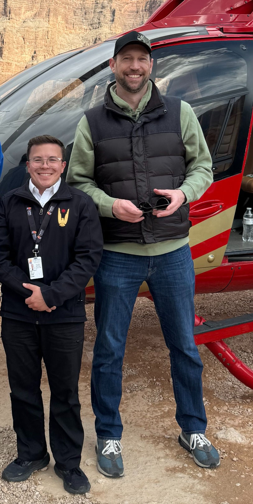
My birthday was coming up the weekend after I was set to leave, so I treated myself to an upgrade for a suite that overlooked the Bellagio pool. In the spirit of "Yes, and…" I wanted to have a unique, adventurous experience, so I booked a helicopter ride through the Grand Canyon the day before the conference started.

I was picked up at my hotel by the world’s worst shuttle driver. He hit every speed bump at full speed and kept pumping the brakes unnecessarily. I sat behind a middle-aged British couple. The man must have been at one of the many indoor gun ranges in Vegas the day before. He showed his wife video after video of him shooting guns - at full volume.

(February, 2011)
I checked in at the airfield and was grouped with five other passengers. We were introduced to our pilot Nathan who was the living embodiment of a munchkin. Super cheerful, a big smile and pocket-sized.
Nathan started a music playlist beginning with the Game of Thrones theme as we took off. He flew us first past the Hoover Dam. Having just driven on it a week before, it was amazing seeing it from this vantage point.
Next he flew us over Lake Mead. He shared some of the lake’s history with us, including the time in 2022 when a drought brought the water level so low they started discovering bodies. One had been stuffed in a barrel in an apparent grisly mob hit.

He then took us up the Colorado River, explaining the green waters get their color from leaching the high copper content out of the surrounding the rock.

As we followed the river upstream, Nathan turned a corner and suddenly there we were - flying through the Grand Canyon.
He explained that each visible line in the rock represented roughly 10,000 years of erosion, and that the canyon was two miles across where we were. He pointed out the famous Glass Skywalk as we flew past it.

We landed on a plateau along the edge of the canyon and stopped for 30 minutes to walk around and have a “champagne picnic”, which consisted of a plastic glass of cheap bubbly, a granola bar, and some string cheese.
Nathan flew us back and a different shuttle driver (thank god) dropped me back at my hotel. I got a massage at the hotel spa, freshened up, and headed out to my first client dinner of the conference.

Over the next few days I had a successful conference, but if you’ve done one trade show in Vegas, you've done them all.

I did some rough math and if you add up all the time I’ve spent in Vegas for conferences and personal trips, I’ve spent over 4 months there (and I don't want to know how much money).

My last night in town, after the show was over I treated myself to a tasting menu at Restaurant Guy Savoy. I really pampered myself in Vegas outside of work. After a good week, I left again for Utah feeling sufficiently self-indulged and celebrated.

BACK TO UTAH
I retraced my steps, did the same scenic drive through Zion, and stayed in Kanab proper the first night. In the morning, I doubled back to Mount Carmel Junction to have breakfast at the Thunderbird Restaurant. Mount Carmel Junction was established by Jack & Fern Morrison in 1932. They built a service station there to support the truckers that came through and Fern made them pies.

In 1940 they opened the Thunderbird Cafe & Restaurant. Jack created the “Pie Girl” figure fashioned after Fern. The story goes that wood was scarce during the war and there wasn’t enough room on the sign to write “Home Made”, so they wrote “Ho-Made Pies”. In the 60’s when “ho” started being used as a synonym of “whore”, they leaned into the cheeky new meaning of the sign, making it part of their marketing.

BELLY OF THE DRAGON
The first stop was less than a mile down the road. The Belly of the Dragon started as a man-made drainage tunnel for rainwater to flow under Highway 89 rather than over it. Periodic flooding reshaped the soft sandstone, creating a rippling tunnel 15 feet in diameter that looks like it could be the trachea of a huge beast.

BRYCE CANYON
The plan was still to hit all five of the national parks along Southern Utah. I had already been to Zion, so I had four to go. The next one on the list was Bryce Canyon. As I climbed in elevation on my way to the park, snow began appearing alongside of the road. Nearing the park, the surrounding landscape took on a deep rusty orange color, and the road led through picturesque stone arches.

State Route 63 runs north to south through the park, along the western edge of the canyon. Scenic viewpoints, hiking trails, and campsites appear as little off-shoots from the road. I didn’t have time for a hike down into the canyon, so I just stopped at a couple of the view points.

The view of the vast canyon with its brightly colored rock, topped with patches of snow was spectacular. At Sunrise Point I made Splatt the Smallest Snowman, so named because of the nose dive he took moments after I took his portrait.

CAPITOL REEF
Capitol Reef National Park was the next up on the list. Just a short way into the park, there is a turn off for Panorama Point. As the name would suggest, it offers sweeping views of sandstone cliffs along one side, and shrub-covered desert on the other. A short walk led me to a rock outcropping I could walk out on that offered a stunning 360 degree view.

Next, I started down the Scenic Drive through the park, hugging more imposing sandstone cliffs. Just past the Grand Wash I had to turn around because I was losing light. I doubled back to Torrey for dinner, then drove through the park on my way to my destination for the night, Green River.

It was just a couple of days from a full moon, and there were few clouds in the sky. I was out in the middle of the desert with no light pollution from nearby cities and almost no one was on the road with me. The moon shone brightly, lighting up the surrounding landscape in a soft blue hue.
I pulled off the road into a small parking area to marvel at the beauty of the night. On a whim, I tried taking a picture to see if the moon was bright enough for the camera to register the nearby cliffs. What I captured absolutely stunned me.

Before leaving on the trip, I went to the Apple store to replace my 10 year-old laptop. While there, I looked at new phones. The associate showed me some of the amazing capabilities of the iPhone 15's new camera, including Action Video setting and the incredible new zoom clarity. I was convinced enough to get the phone, and it's one of the best purchases I could have made.
I had absolutely no idea that the new phone cameras have a Night Mode which allows you to take incredible pictures in almost zero light without a tripod.

Throughout the rest of my drive to Green River, I kept stopping to take more night photos in the desert.


UTAHRAPTOR STATE PARK
In the morning, I decided to skip Canyonlands and just focus my time on Arches. There was a lot to see there and I wanted to make some good progress into Colorado before the day was over. I felt pretty good about getting to four out of the five.
Coming from Green River, I was approaching the park from the north but the main entrance was at the southern end. My map however, put me on a path to enter the park closer to the north end on what appeared to be a small, unpaved, side road.

(not my photo)
The road came out of nowhere and was difficult to spot, so I missed the turn. The map quickly rerouted me to the next side road into the park, so I just stayed on the new course. When that road came up, I turned onto a dusty road marked by a sign reading Utahraptor State Park. Utahraptor was the name given to the new species of dinosaur whose fossils were first discovered in 1975 in that part of Utah. Think velociraptor but bigger and with feathers.

(not my photo)
I drove past a few RVs and people tent camping in the dirt then followed the road my phone was leading me down. The terrain went from rough to rougher. Giant potholes became more frequent, as did the washboarding in the road. It was slow going. At one point I rode a small hill down into a dry wash, the deep sand shifting under my tires. I had to speed up to get 100 feet down the wash to where the road continued before getting stuck.

(not my photo)
My next obstacle was a crater in the road five feet wide and two feet deep. I had to drive off the road, my inside wheels skirting the edge of the hole, to get past. Around the next corner, the road went over a forty-foot expanse of rock with a two-foot deep hole near the end.
I stopped the car to look for an alternate path around the hole. I thought I saw a way up around the rock to the left, but should I do it? At that moment, a mountain biker came the opposite way on the road, and a 4x4 Jeep came up the road behind me. They both looked at me like I was an idiot as they went by, which seemed pretty accurate.
Sometimes discretion is the better part of valor, so I drove back out the way I came in.

I looked up Utahraptor State Park later. Its site explains that the state park is “currently undeveloped with only primitive recreation options.” and that “Future park visitors to the area can expect one modern campground…and trailheads for access to the nearby OHV and mountain bike trail systems. I looked up what OHV stands for and it’s “Off-Highway Vehicles”. Fuckin' Apple Maps. It’s probably for the best that I didn't push my little car any further than I did.

I decided on the precarious drive back to the highway that my little Rogue had done so well, it finally deserved a name. Back on the road, as I drove the rest of the way to the main park entrance, I brainstormed ideas that incorporated "Rogue" in the name.
I finally decided on PieRoguei because it’s shaped like a dumpling and stuffed with my things. I'm still not sure on the spelling - Pe-Rogue-i?

ARCHES
I finally entered Arches via the main entrance and started driving north through the park. The first turn-off was for Park Avenue. On either side of me, sheer cliffs of rock stretched toward the sky, narrowing the space between them as they approached the horizon. Looking at them, it made sense that this area got its name because the rocks resemble rows of skyscrapers.

The cliffs on the right were actually thin fins of rock. They looked fragile and precarious from afar, but so massive up close it was hard to imagine them moving.

Next, I took the spur road to the Windows, passing by Elephant Butte along the way. Elephant Butte is a flat-topped cap, which stands as the highest point in the park. I stopped and took a picture of this rock, which I thought looked like an elephant. I was convinced it must be Elephant Butte - it was not. It's not just me, right?

The Windows are one of the most iconic areas of the park. When looking at The Windows straight on, they look like a giant beast’s eyes with an outcropping of rock between them forming the nose.

The scale of these arches is difficult to describe, but it’s impossible not to feel minuscule in their presence.

It was a short walk up to the North Window. Once I got to the arch itself, the desert stretched out below me for miles. It is no wonder that these natural features played a large role in native peoples' religious ceremonies, and were described by them as portals in space & time.

I took a different path back to the car, past Turret Arch.

I stopped at the bathroom before leaving and noticed this sign. Imagining what must have happened for them to put this up gave me tremendous sympathy for all of the wonderful people who keep our parks accessible and maintained.

There are over 2,000 of these arches in the park. If you’re curious about the geologic forces that formed these arches, the National Park Service does a good job explaining it here.

Next I drove to see Delicate Arch, which is so iconic they put it on the Utah license plate. When I got to the parking area and saw the 1.6 mile uphill hike thronged with people, I decided to skip it. I had already seen so many amazing things in the park, and in Utah overall, I just wanted to get as far into Colorado as I could before the sun went down.

(not my photo)
Not wanting to drive the entire length of the park back south to exit the way I came in, I studied the paper map I got at the ranger station to see if there was another way out. Near the north end of the park there was an “unimproved road” that led to the highway, and despite my morning’s misadventures, I took it.

This road out of the park turned out to be a plain dirt road, which provided a beautiful drive through desert and grassy plains. This was the road my phone had intended me to take the first time around.
In the land beyond the park, cows roamed free and grazed along the road, kept in only by cattle guards at a couple of gates.

Turning right on the highway in the afternoon light, my head was spinning with all the incredible things I’d seen in Utah. The diversity and spectacle of its natural beauty was astounding. I had barely scratched the surface, and would go back in an instant, but that day I drove to Colorado with a heart full of wonder and a head full of memories.
Yes, and…
Matt

Comments