Physical State of Matt #32: MINNESOTA
- 50statesofmatt
- Feb 2
- 17 min read
As soon as I crossed the Red River of the North into Minnesota and passed through Moorpark I saw loads of trees, a welcome sight after the endless North Dakota plains.

A gas station that had been converted into a Trump Store for the election stood along the highway, forlorn and empty eight months after the voting.

After an hour in the state I cut north off of state route 34 toward Itasca State Park, my first stop and home to Lake Itasca. Minnesota’s state motto is “Land of 10,000 Lakes”, which may sound like hyperbole but, as I discovered in my drive through CANADA, the number is actually 11,842.

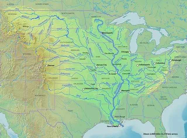
The original Ojibwe name for the lake was Omashkoozo-zaaga'igan, or Elk Lake. It was renamed by explorer Henry Schoolcraft after discovering it in 1832. Schoolcraft’s expedition endured “voracious, long-billed, dyspeptic musketoes (sic)”, but in Lake Itasca they found what they had been seeking - the headwaters of the Mississippi River.
The name Itasca is a combination of the Latin words veritas caput, or “true head”. Why "true" head? Read on dear friends, and all shall be made clear. From Lake Itasca the river flows 2552 miles south where it empties 200 billion gallons of water per day into the Gulf of Mexico.

I found the small, tranquil lake at the end of a short path from the parking lot. A few children shouted and splashed in the water where the lake funneled into the very start of the river. I removed my shoes, rolled up my pants, and waded through the 18 feet of shallow water. It was warmer than I had expected.
I stopped for dinner in the small town of Bimidji, where I had attended summer camp when I was fourteen. Concordia Language Villages offers several sleep-away camp experiences. I was enrolled in a 2-week coed French immersion camp designed to mimic the life of the French Voyageurs - groups of French, and later French Canadians, who transported furs through the region by canoe in the 18th and 19th centuries.

The first week we learned camping and survival skills, cooked over a fire, and swam in Lake Bimidji. The second week we took a three-day canoe trip to Cass Lake, where we camped for four days on L’Ile de L’Etoile (Star Island).

I have vivid memories of that summer, guiding my canoe through the reedy streams that connected the string of lakes, jumping off of tall sand bluffs, and grappling with some early teenage crushes. I remember a group of us dragging our sleeping bags onto the sandy beach of Star Island and falling asleep watching the Northern Lights dance in the sky.
Seeing Northern Lights in the summer is highly unusual, so I factchecked myself and it turns out that 1990 had the third strongest lights in the last 300 years, visible in the northern US throughout much of the summer. So that's my story and I'm sticking to it.

Bimidji is a small lakeside city with a cute downtown. It is one of the 11 cities (including Bangor, MAINE) that claims to be the home of Paul Bunyon. I recognized their iconic statues of Paul and Babe the Blue Ox, still standing on the shore. The #BIMIDJI sign was new.

I continued west as dusk threatened to overtake the warm summer evening. Spotting a clearing in the woods, I pulled in to explore. The area was being logged. Neat stacks of freshly cut trees towered above me and heavy equipment lay dormant for the evening.

Driving away, the sunset was so intense I could have sworn the evil Eye of Sauron was looking for me.

The sky began to darken and the sliver of a moon appeared. The air cooled and a thick ground fog rose on both sides of the road. The sunset felt like it lasted forever, and I was not mad about it.

I hadn’t planned a destination for the day, figuring I’d drive until I got tired and stop there. The problem was that once I passed through Grand Rapids there was little in the way of civilization. The two area hotels that had vacancies offered meager accommodations in exchange for my first born. Not having one, I pushed on to Duluth.

Duluth is a center for shipping at the western point of Lake Superior. Its long bridges and lakeside docks make the city picturesque in an industrial sort of way. I booked a hotel over the bridge from downtown which, to my surprise, turned out to be in Superior, Wisconsin.

The Androy Hotel was a relic from the roaring 20’s with a few modern amenities for show, but it was located right on Tower Ave., a lively strip with several entertainment options. I ended up at Palace Bar eating a microwave pizza and drinking Pickle Twisters, drinks made from pickle juice and vodka, served from a machine with an ever-swirling green vortex.

LAKE SUPERIOR COAST
The following morning I had a huge breakfast at the diner-style restaurant inside the hotel. The waitress gave me a laundry list of things to do the following week when I visited Wisconsin. I crossed back over the John A. Blatnik Bridge into Minnesota and followed the coast of Lake Superior northeast.
Following a recommendation from one of my new friends in Sandusky, OHIO, I stopped at Russ Kendall’s Smokehouse for some smoked cisco, a small local fish, and wild rice. Smoked fish, a Minnesota staple, draws on the culinary history of the state's Swedish and Norwegian immigrants.

Minnesota wild rice, or Manoomin, is not in fact a rice at all, but an aquatic grass. Manoomin is central to Ojibwe history and culture, and was adopted in 1977 as the official state grain. Its long, dark grains have a rich nutty flavor and are incredibly high in protein and antioxidants. And boy, does it pair well with smoked fish.

Next was pie. I love pie. I love pie so much that at my wedding we didn’t have cake, we had pie. I stopped for pie twice. First was the famous Betty’s Pies, located on Voyageur Highway in Two Harbors.

Their selection was incredible, and their parking lot was understandably packed. No strangers to high volume, in addition to their dining room, they manned a busy to-go window with a snaking line. I got a slice of the Great Lakes (rhubarb, apple, strawberry, blueberry, and raspberry), which left me weak in the knees.

A short way further up the road, I saw a sign for a small town called Castle Danger. It was such a cool name I pulled into the parking area of the Rustic Inn Cafe. The area got this name from early sailors. Castle came from the towering cliffs, and Danger from the treacherous reef between them.
There was a collection of rental cabins, the cafe, and in the parking lot…a pie truck, Pie on the Fly. This time I got a slice of the Lemon Angel, which was like a lemon meringue pie, but creamy. Mmmmmm

North of Castle Danger, cones of purple lupine exploded along both sides of the road with the occasional bloom of pink or white. There was a heavy fog hanging above a few hundred feet offshore and the drive was spectacular.

I stopped to take in a scenic view shortly after I passed through the Silver Creek Tunnel.

Walking the paved path up to the viewpoint, rock climbers practiced scaling the cliff. I could still see, etched into the rock face, the marks of the rods used to drill down and shape the rock when they built the tunnel in the early 90’s.

The viewpoint offered sweeping vistas up and down the irregular coast. To my south, a lonely gazebo perched on a cliff.

Eastward, the view of the lake was split into three perfect bands of blue: sky, fog, and ocean.

Next up the coast was one of the most photographed lighthouses in the United States - Split Rock Lighthouse.
Lighthouses are generally something that one associates with oceans, not with lakes. But the Great Lakes, and Lake Superior in particular, are an exception to just about every rule. At over 31,000 square miles, Lake Superior is the largest freshwater lake in the world by surface area. It is third largest by volume and contains 10% of the world’s surface fresh water.

The amount of water in Lake Superior - 3,000 cubic miles or 3 quadrillion gallons (that’s 3,000,000,000,000,000) - is so voluminous as to feel abstract. To think of it another way, Lake Superior holds enough water to cover all of North and South America under a foot of water. Let that sink in.
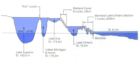
Lake Superior is a critical piece of the US and Canada’s shipping systems. It is an essential link in the Great Lakes-St. Lawrence Seaway System. Coal, grain, and nearly all of the iron ore mined in the US passes through the Soo Locks, which connect Lake Superior to the rest of the Great Lakes. 42 million tons of goods pass through its ports including major ones at Duluth-Superior and Thunder Bay, Ontario.

Its weather patterns and water conditions can be as treacherous as an ocean. There are 75 lighthouses along its 2730 miles of coastline. Around 550 ships are known to have wrecked on Lake Superior, earning it the name “Graveyard of the Great Lakes”. None of these are as famous as the Edmund Fitzgerald.

The Edmund Fitzgerald was a 729-foot freighter, the largest ship on the Great Lakes at the time of its launch in 1958. It primarily carried iron ore from mines near Duluth to iron works in Detroit and Toledo and set the seasonal haul record six times during its 17-year run.

On November 10th, 1975, the Edmund Fitzgerald was caught in the eastern part of the lake near Sault Ste. Marie by a storm with hurricane-force winds and 35-foot waves. At 5:30pm Captain McSorely reported the ship was experiencing difficulty with the storm. He radioed again at 7:10 saying “We are holding our own.” Shortly after, the ship sank suddenly without sending a distress call, killing all 29 crew members aboard.

Gordan Lightfoot’s song “The Wreck of The Edmund Fitzgerald” came out the following year and rose to number 2 on the billboard charts. It must have been a really slow year for music.
The shipwreck remains a prominent chapter in Great Lakes lore.
The Split Rock Lighthouse sits atop a sheer cliff, 130 feet above the lake. It was built in response to the 1905 Mataafa Storm, which sank or damaged 29 ships on Lake Superior, and was completed in 1910. It served as an active lighthouse until 1969 when advances in navigation technology rendered it obsolete. It was turned over to the state and became a State Historic Site. They still fire it up every year on the anniversary of the Edmund Fitzgerald's sinking.

I found the grounds around the lighthouse under renovation to support the large number of visitors they get each year. As I mingled through the crowd, waiting my turn to climb the lighthouse, a small yellow plane buzzed by the lighthouse at my eye level, shockingly close.

Climbing to the top of the 54-foot structure, I found its 7-foot wide lens, slowly rotating just like it did 60 years ago, its 252 prisms glinting in the sunlight. Below, at the visitors center, an identical replica spun so I could get a better view.
After a fifteen minute walk down to the shore along a paved path with stairs, I had the best view in the house - looking right up at the lighthouse from the shoreline.

GRAND MARAIS
I had never heard of Grand Marais, but chose it because Cassie, a reader of the blog, reached out to me on Instagram to suggest it. Not only that, she went above and beyond, sharing a four-page itinerary with suggestions for accommodations, restaurants, activities, and more.
I had underestimated what a destination Grand Marais is during the summer. I found my accommodation options severely limited and very expensive. I booked a small cabin for a couple of nights about 20 minutes south of the city along the coast. I’d get to as much on Cassie’s list as I could in that time.

In the morning I drove into downtown, finding Grand Marais Harbor swathed in fog. I grabbed a Salty Seagull (white chocolate & salted caramel latte) at Java Moose, a community fixture. They've been in business for 34 years and, unlike most seasonal businesses, they stay open year round. They hang on through the tough months so they don't have to lay anyone off. That's the kind of people I met throughout Minnesota.

I then had Swedish pancakes at the Blue Water Cafe, and walked the downtown streets. It was bustling with summer tourists. Galleries and shops displayed local wares, and sailboats bobbed gently in the water.

Grand Marais translates to “Big Marsh”. However, it is thought that French cartographers’ confusion between the French word "marais" (marsh) and the French Voyageur word “maré” (sheltered harbor) actually led to its name.

I walked past the shuttered Coast Guard base and along Artists’ Point, a long spit of land that leads out to the Grand Marais Lighthouse. Parts of the path were paved and in decent repair.

The rest of the way I had to clamber across the natural basalt rock that formed the point. This type of rock, when it cracks from regular freezing and thawing, breaks off in straight lines and sharp angles, making it seem unnaturally geometric and blocky.

The marine fog had blown out from the harbor by the time I reached the lighthouse, but it still lingered on the lake. I was treated to an idyllic view of downtown Grand Marais across the sparkling water while the coast to the north and south was still shrouded.

Starting in Grand Marais, the Gunflint Trail is a 56-mile scenic byway that winds its way through the region called the BWCAW - The Boundary Waters Canoe Area Wilderness. This area of Minnesota, which borders Canada, contains over 1,000 lakes and is a destination for boating, fishing, hiking, and other outdoor activities. It was included in National Geographic’s 50 Places of a Lifetime in 2009.

The wildflowers, already breathtaking along the coast, tripled in intensity once I entered the byway. Technicolor walls of purple lupine, orange hawkweed, and yellow cinquefoil guided my way along the winding road through the fields and woods.

Ten minutes before I reached my destination the sky opened up and torrents of rain pounded my windshield. I had my wipers on high, but still had to crane forward to see glimpses of road between the swishing of the blades.
I parked at the Trail Center Lodge and ran inside. Lightning flashed in the brooding sky, thunder crashed and rolled across the lake.
Inside the Trail Center was a small general store that carried the types of things campers need - jerky, dehydrated food, small propane tanks, and tools - alongside the standard tourist fare - postcards, t-shirts, stickers, etc.
I was having a sweet craving so I looked through the candy and, out of nostalgia, picked up a pouch of Big League Chew. This was the shredded bubblegum I used to chew when I played little league and I couldn’t remember the last time I’d had it.

The dining room was decorated eclectically. Vintage yard signs for local politicians and old-timey portraits covered the walls, while antique chairs and a moose skull hung over the tables.

I ordered the walleye sandwich, which turned out to be a slab of fried fish fillet on a toasted roll with two full leaves of lettuce and generous side of perfectly seasoned Minnesota wild rice.

But the real reason I was there was the rhubarb shake - highly recommended by Cassie. It was perfect and served in the stainless steel cup that says they just made it from scratch. The sharp tang of the rhubarb mellowed out the sweetness of the ice cream. It was one of the best lunches I'd had in a while.

The rain had abated somewhat by the time I started the return drive, which it was to say it was now just a hard downpour. As I rounded a corner I swerved to avoid something in the road - an eight inch long turtle, plodding its way across the street.
I wanted to help it get out of the road, but there was no shoulder and visibility was poor. A quarter-mile down the road there was a turn out. I threw on my bright red rain jacket and made my way back along the edge of the road.
A couple of cars drove by as I followed the winding road back. Eventually I found the stretch of road where I thought I’d seen it. No turtle anywhere to be seen - alive or dead. I told myself it must have been faster than it looked and returned to my car, thoroughly soaked.

I pulled back onto the road and tore into the Big League Chew. It occurred to me what a depraved product it is - designed to emulate the cheeks full of tobacco baseball players chew (though not so much any more). Along with the candy cigarettes that make smoke-like puffs of powdered sugar when you blow through them, Big League Chew helps train the smokers of tomorrow. Wild.
By that evening, the sun was out again and the sun danced on Grand Marais Harbor. I stopped at Voyageur Brewing Company for a flight of their brews and some fried cheese curds. Out of respect for to Wisconsin I won’t elaborate on this regional culinary delight here.

NORTHWEST ANGLE
I set out the following morning for Canada. At the tail end of my drive to ALASKA, I had found myself wondering what the northernmost point of the contiguous US is. I’d been to the southernmost point in Key West, why not complete the pair?
I looked it up and discovered the answer was the Northwest Angle in Minnesota. I kicked myself. I'd missed it by only 50 miles and could have visited it with a one hour detour. I vowed to see it when I came through Minnesota later on the trip.

The Northwest Angle is a geographic oddity that I had never heard of, nor has anyone else I’ve discussed it with since. If you look at the northern edge of Minnesota, along the border with Canada, there’s a little bit that juts up strangely.
At the tip of this funny “chimney”, as it’s called, is a little corner of land, separated from the rest of the state by the Lake of the Woods. The end result of this is that in order to get to the northernmost point of the contiguous 48 you need to take a boat or drive through Canada. I opted for the latter.

The reason why this ridiculous 123 square mile chunk of orphaned land belongs to the US and not to Canada comes down to an 18th century cartographic error and decades of bickering.
The Treaty of 1783, which ended the Revolutionary War, determined the northern border of the United States from the Atlantic to the Mississippi River. The Lake of the Woods was thought at that time to be the headwaters of the Mississippi, so they drew the border to the northernmost point of the Lake of the Woods.

In 1803 the US bought the Louisiana Purchase for $15 Million - less than 3 cents per acre. (that's only $430 Million in today's dollars - people spend almost that much to make a movie!). To connect the lands, they drew a line straight down from the Lake of the Woods.

The Treaty of 1818 redefined the border as the 49th Parallel from the Mississippi all the way west to the Rocky Mountains. Since the northernmost point of the Lake of the Woods was still north of the 49th parallel, they kept the top piece of this north-south line.

Though explorer David Thompson proved in 1798 that Lake of the Woods was not actually the headwaters of the Mississippi, America refused to concede a border change, and rejected several attempts to buy the Northwest Angle. You’ll recall that in 1832 Henry Schoolcraft determined that Lake Itasca was the true source, but possession is nine tenths of the law. America refused to budge, and that's how we got the Northwest Angle.
I followed my map off of the highway shortly after crossing into Manitoba, and the roads got progressively smaller as I went on. The final 35 miles were all dirt roads with no cell signal. Thick woods with patches of swamp bordered the road.
I stopped at a sign that said "10 miles to the US border" and realized that my car was in the center of a buzzing swarm of silver-dollar-sized flies. Or were they bees? They were moving too fast for me to tell. I eased Pierogi forward but the flies kept pace. It wasn’t until I hit 25 miles per hour that they finally fell behind.
The border crossing back into the US was simply a sign saying that I had to stop 8 miles ahead to self-report to US Customs at a place called Jim’s Corner. Apparently they're on the honor system up there.

Eight miles further along I found Jim’s Corner. It wasn’t a gas station or market like I had assumed from its name, but a dirt lot at a T intersection with nothing but a phone booth.
The flies returned the instant I stopped driving. I was in a pickle. Did they bite like horseflies, or were they possibly super hornets ready to sting the shit out of me by the time I could make it to the booth? Would they swarm inside the car as soon as I opened the door and be impossible to get rid of? I tried to look the insects up on my phone, but there was still no reception. What if I just didn’t call Customs?

I'm not proud of it, but I sat in my car for ten minutes debating my limited options. Eventually a pickup truck pulled into the lot with a pair of guys from a nearby road crew. The one on the passenger side opened his door, passports in hand, and walked to the booth like it was no big deal. The flies paid him no attention. I felt relieved and more than a little silly. A three minute conversation with US Customs and I was on my way.
The end of the road opened up into a large parking lot with a couple of small businesses, presumably supported by the boaters that came over from the mainland. In the grass near the shore was a green buoy. Although it's a pair with the red one in Florida, the experience of visiting the two couldn't have been more different.
A woman who was staying at the lodge came over and offered to take pictures for me. We chatted for a bit, then I headed back - fucket list sidequest achievement unlocked.


CANADA DAY
I grabbed a hotel in Winnipeg for the night. Chatting with the bartender over dinner, I learned that the following day was Canada Day, the annual celebration of the nation’s confederation on July 1st. It’s sort of like Canada’s fourth of July.
Not knowing when the next time was I’d have a chance to see this, I extended my stay for another night. She recommended I drive an hour north to Gimli to see their parade. The town is the Icelandic cultural center in North America, and was settled in the 1800’s as New Iceland. They host the annual Islendingadagurinn (Icelandic Festival of Manitoba), she told me, so it was worth a visit.

More yellow fields of canola appeared sporadically on my drive North, interspersed with fields covered in light blue flax flowers.

The streets of downtown Gimli were lined with spectators, bedecked in red and white. A man walked along the edge of the street, handing little Canadian flags out. Others tossed candy to the children crouched at the front for the best view.

I had been expecting a viking-themed parade in keeping with the town’s identity, and it started with a float from the local Icelandic festival, but that was it.

The rest of the procession was the standard fare you’d expected at a small town parade. Among other things, there was the Canada Day queen, poking regally out of the sunroof of a pink Cadillac SUV, driven (as best as I could tell) by a shark and a lion.

There was the world’s smallest school bus.

And there was a giant purple Crown Royal truck. Apparently the sole Crown Royal distillery is nearby and is a major employer in the area.

The cherry on top however, was an unhoused man who brought up the rear of the parade on his bicycle, towing a hitch basket full of his things. He waved to the crowd like he was an official part of the festivities. Shit, for all I know he was.
Although the parade wasn’t what I’d expected, it was a charming piece of Canadiana and I was glad I’d gone.

Back in Winnipeg, I found the local park where the main Canada Day gathering was happening. I arrived around 6:00. The music was over, the crowd was dispersing, and all of the food carts were packing up. I was surprised to find it ending so early, but set about to find the city’s main fireworks display. As I approached the spot, an angry summer storm blew in with wind, rain, and lightning. Fireworks canceled.

Based on my limited experience with Canada Day, it seemed similar to July 4th in the US, but more lowkey without the aggressive patriotism and widespread binge drinking.
I booked an Airbnb in Wisconsin before heading back over the border. The plan was to stay the night in Minneapolis-St. Paul and visit the hometowns of my friends Brad and Kevin on the outskirts.

As I approached the city, I got a notification asking me about my check-in experience. Confused, I double checked my reservation. I’d booked the wrong days and I was due in Wisconsin that night.
So, instead of stopping, I drove straight through the Twin Cities and kept heading west. It was going to be a late night, but I was determined to make it.
Yes, and…
Matt


Comments