Physical State of Matt Interlude: CANADA
- 50statesofmatt
- Jul 6, 2025
- 23 min read
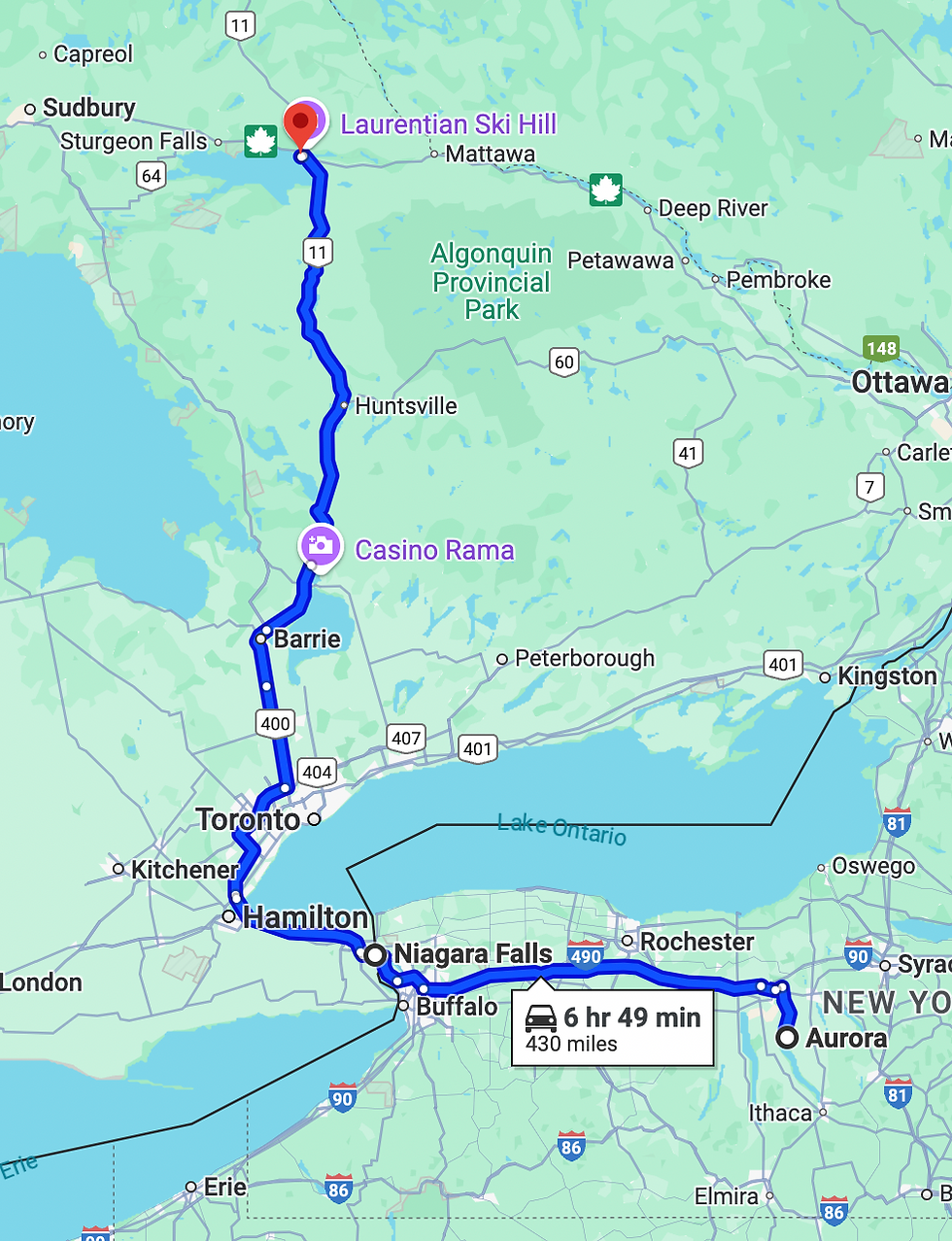
The driving route from Ithaca to Fairbanks, Alaska took me over 4,200 miles through 6 Canadian provinces and territories in sub-zero temperatures. This was the first time on this trip that I was sincerely nervous.

My M.O. for this journey has been to go with the flow, follow locals’ recommendations, basically prepare as little as possible and see what happens. I prepared for the drive through Canada like I’ve never prepared for any trip in my life. I can be a little cavalier, but a remote breakdown in Canadian winter without the right equipment has the potential to be life threatening.
I ordered boxes of gear and supplies and shipped them to my friend Larissa’s house near Ithaca. I spent the days before I left getting new snow tires and reconfiguring everything in my car so that I was prepared for a worst case scenario.

My mom let me pick through a bunch of Jeff’s old safety gear from his national park trips. She also loaned me her super warm sheepskin hat and wool scarf, which were quite fetching.

My friend Carolyn, who I’d visited in MASSACHUSETTS, introduced me to one of her colleagues, Ben. Ben grew up in the remote area of Alaska close to the Canadian border. He knew my whole route well, having driven it several times himself. Most importantly, he was knowledgeable in the area I’d be driving through the last few days - the most remote wilderness.

Ben was an angel, and so was his family, but I’ll get to that in my Alaska post. For now, what’s important is that Ben helped me put together my packing list. One of the things he recommended was the Milepost.
The Milepost is a paperback tome published annually with detailed information on every town and road in Northwestern Canada and Alaska. That thing is dense and packed full of lifetimes worth of cool knowledge and helpful tips. Of course, there is a digital version too, but since huge swaths of the area have no cell service, it’s helpful to have the analog one.

I had broken up the trip into 11 days of driving, which averaged out to a little over 400 miles per day, a challenging but manageable pace. I wanted to avoid driving at night since a sudden meeting with certain Canadian wildlife on the road would be unforgiving, and I was told they have a tendency to pop up out of nowhere. I was really excited to see moose, bear, and bison, just not coming through the windshield.
I had planned my route to go almost entirely through Canada. Although it added a couple of hours to do it that way, I’d only ever been to a few places in Canada, and I wanted to do something brand new. Besides, when you’re driving 70 hours, what's a couple more? Why did I decide to drive rather than fly? I was just dumb enough to think it would be fun - and I was right!

I didn’t have enough time for a lot of sidequests to take pictures, so I tried a little experiment and made daily videos of the drive which I posted to Instagram. I’ve added them here, but they don’t have the titles which I added in Instagram, so please forgive the couple of seconds of black at the beginning of each one.
DAY 1
I was excited and nervous when I left Larissa’s house. I felt solid about the plan, but there was so much unknown. Despite all the planning I’d done I truly didn’t know what to expect. The first day of driving was around 430 miles up to North Bay, Ontario.
I crossed over the border near Niagara Falls. Canadians have a reputation for being nice, and it’s held true in my experience. I was wearing my 50 States of Matt hat that first day. When I stopped periodically for food and gas, it got several sideways looks and comments about it.
It was a strange time to be an American in Canada. Two days before, Trump had imposed a 25% tariff on goods imported to the US from Canada. In addition, he had been talking haphazardly about making Canada the 51st state. It was the spiciest I’d ever seen Canadians, which is to say only moderately nice.

Once I got past Toronto and into rural Ontario, I experienced my first blowing snow advisory of the trip. It affected visibility, but it was so cold that the snow wasn’t sticky or slippery. I arrived in North Bay just after dark, and got an exceptional pizza from Arugula. It was probably the excitement from starting the trip, but I had a hard time sleeping that first night.
DAY 2
My second days’ journey took me 500 miles on a northwesterly arc through Ontario to Longlac. I had been told that road conditions would get worse the deeper into Canada I got, so I wanted to front load as many miles as I could.

Day 2 was a long one, and it got started just after dawn. Running on only three hours of sleep, I hit the drive-through at Twiggs Coffee Roasters and made sure to get extra shots in my latte.
I spent the entire second day on the road. By the late morning, the cloud cover cleared. The sky was a brilliant blue, the sun sparkled off of snow drifts. The landscape changed and I began to pass dozens of small lakes. I was really, really tempted on several occasions to stop the car and walk out onto the ice, or roll across it to one of the small islands. I was quite sure the lakes would be completely frozen over…right?

I made it to Longlac as the sun was approaching the horizon. I spoke to the front desk clerk at one of the hotels and inquired about a room. I wasn’t thrilled with the combination of price and quality. Looking online, I saw there was another hotel 20 miles further along. It was the same price, but seemed nicer. I hopped back in the car, which was very quickly getting coated with road salt, and in a short time checked into the Between Bridges Inn and Restaurant.

The Inn was run by several wonderful Thai women with great senses of humor. When I was checking in, I asked the front desk clerk if I could safely walk out on the lake across the street. She gave me a cagey look and said “Some people have succeeded".

The Inn’s restaurant offered American, Canadian, and Thai dishes. While I ate my steak and poutine, I listed to the guy next to me, in a THICK Canadian accent, have an in-depth conversation about Thai ladyboys with the bartender.
DAY 3
Day 3 was a 470 mile bruiser of a day. In the original itinerary, I had set my Day 3 destination as Winnipeg, but I realized in the morning that was overambitious and targeted Kenora instead.

When I stepped outside, the temperature was -1 Fahrenheit. As I took my first breath, it caught in my sinuses and I felt all the moisture in my nose begin to crystalize. This was the first of many “frozen booger” days.
I stopped for coffee at Robin’s Donuts in nearby Geraldton. The small town was rather bleak, covered in ice with very little activity, but the donuts were good.
As I continued through Ontario there were lakes everywhere. I was driving just north of Minnesota, Land of 10,000 Lakes, so that made sense I told myself. Turns out Ontario has 250,000 lakes, most of which aren't even named, that make up almost 20% of the world’s fresh water supply. How do you like them apples Minnesota?

I finally gave in to my childish urge to roll across the ice and pulled the car into a parking area with lake access. This lake was larger than most of the others, but given how cold it was, I was sure it had to be frozen over - right?
When I arrived at the shore there were dog tracks across the ice, which was a good sign. But there was also a small trickle of water flowing into the lake that was still liquid, which was a bad sign.

I finally decided on the prudent approach and walked back to the car. It would be silly to have gotten all of this safety gear for the drive only to fall through the ice in the middle of nowhere for no good reason.
Kenora was a charming little city on Lake of the Woods. I checked into Nature’s Inn - and no, that’s not a euphemism for camping. Hell no. That evening, I walked through downtown and poked my head into several bars and restaurants.

I was struck by how many of the people I saw were of native descent, most of them presumably of the Ojibwe First Nations. I had a wonderful dinner at the Boathouse Lakeside Grill, and called it a night.
DAY 4
Because I’d stopped short of Winnipeg the previous day, I had another 500 mile marathon ahead of me. I wanted to get to Regina, Saskatchewan by the end of the day. My friend Brad had worked on a movie that was shot on location in and around Regina, so I wanted to make it to the city - not that I would have the time or energy to actually do anything while I was there.

As I drove into downtown Kenora, I had to stop for three very substantial deer in the road. They grow 'em big up there. When I got to HoJoe Coffee and Eatery, I found it closed on Sunday. How do you close a coffee shop on a Sunday?!
The Hungry Pug didn’t open for another 15 minutes so I chilled in my car, literally. The food was fantastic and the French-Canadian waitress was charming. It made me glad HoJoe had been closed. The cook and I got into a fun conversation about independent cinema of the 90’s and early 2000’s. Come to find out, he ran a video store in town back in the day when, you know, people rented physical movies.

A couple hours after starting my drive, the scenery suddenly changed. No longer was I driving past the rocky outcroppings and pine trees of Ontario. I was in the endless plains of Southern Manitoba. The highway skirted Winnipeg, and took me straight - very straight - all the way to Regina.
I booked the Holiday Inn on the outskirts of Regina because they had a hot tub. I dropped my bags and put on my swim trunks. The hot tub was indoors next to the pool, which had a full two story waterslide. Never seen that before. I soaked until they kicked me out then DoorDashed some asian noodle thing. I was wrecked.
DAY 5
The third and final 500 mile day took me from Regina to Edmonton, Alberta.

In the breakfast room of the hotel, CBC News was announcing the results from the Liberal Party leadership election. Mark Carney was going to succeed Justin Trudeau - the first new Prime Minister for Canada since 2013. True, he would only hold the office for a month and a half before facing a general election, but it felt like a really big deal.

The landscape didn’t change one bit throughout the day. It was the hardest day of driving on the whole trip - eight hours of monotonous, featureless farmland and prairie. The only interesting things that happened were two wildlife sightings.
I saw the first moose of my life - a female chilling in a small copse of trees along the side of the highway. Second, I spotted two wild wolves prowling the edge of the fence that ran along the highway. Both were very cool moments.
I found a great boutique hotel in Edmonton, The Meterra Hotel on Whyte. It was located in the Old Strathcona neighborhood which started as a separate town, but was absorbed as Edmontown grew. It's a vibrant area of the city with historic buildings, cool shops and neighborhoods.

I decided after a grueling five days on the road that I was going to treat myself to a day off. The weather had held and I was on schedule. I booked two nights at the hotel. It was a modest upgrade to get a suite with a fireplace, so I went for it. I then had a sumptuous dinner at pip.
On my day off I slept in, lounged around, took a bubble bath, caught up on editing, and generally recharged.
DAY 6
The destination for Day 6 was a mere 365 miles northwest of Edmonton, just over the border into British Columbia - Dawson Creek.

90% of the Canadian population lives within 150 miles of the US border, and I was pushing into remote, sparsely populated areas.

The landscape started changing slowly around me - some hills again, some trees. With an hour left in my drive the highway went back to two lanes and it started to snow. I stopped in Beaverlodge to visit the Giant Beaver Attraction, then finished my drive before I got frostbite.

While they got my room ready at the Pomeroy Inn & Suites, I had dinner and a soothing hot toddy at Post & Row, a killer brew-pub on the main strip.

When I returned to the hotel and parked I noticed electrical outlets on 3-foot posts in front of every parking space. Google informed me that these were for block heaters. It gets so cold in that part of the world that people have to use these devices to warm their engine blocks enough for their vehicles to start. Yikes.

That night I was far enough north to start checking the My Aurora app to see if there was any possibility to see the Northern Lights.

There was good activity and there was a decent possibility to see them. Unfortunately the sky that night was overcast, as was every one of the remaining nights I was in Canada.
DAY 7
A modest 280 miles deeper into British Columbia was Fort Nelson, my destination for Day 7. This was the start of the Alaska Highway, or ALCAN, which officially runs 1,400 miles all the way to Delta Junction, Alaska. Unofficially, it runs another 100 miles to Fairbanks. This would be the only road I would travel the rest of my way.

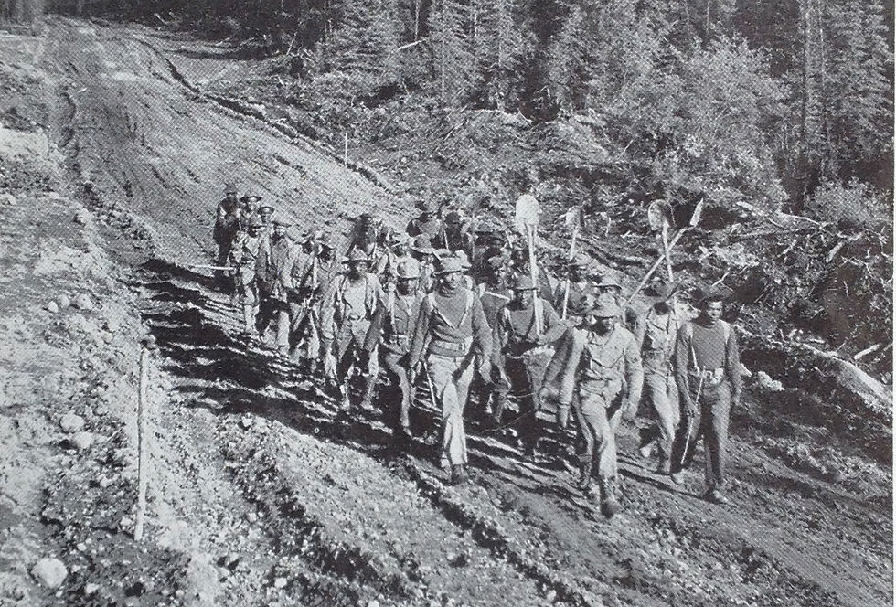
Construction on the ALCAN began in 1942, shortly after the Japanese attack on Pearl Harbor. It was built primarily by the US Army Corps of Engineers as a supply route. They assigned 10,000 men to the task, a third of them were black soldiers from newly formed segregated regiments.

Canada allowed the US to build the highway through their country provided that we cover the full construction cost and turn it over to them at the end of the war, which we did in 1946. There are still collaborative maintenance agreements between the governments today to support upkeep of the highway.
Although the ALCAN is not the only road going between Canada and Alaska, there are very few others and it’s by far the most used.
I started the day going into downtown Dawson Creek to find coffee and stumbled on one of my new favorite stores. Faking Sanity is a crafts / used books / coffee / yarn store. The two people who ran it were incredibly friendly. They told me all about starting the store and made me a mean cup of joe!

My driving path took me along the edge of the Canadian Rockies. As the day went on, I was climbing larger and larger mountains. I stopped for gas and a smokie (basically a hot dog-like sausage filled with cheese) at the midpoint atop Pink Mountain. A snowy, pine-covered expanse stretched out before me. This was more like it.
I met a father and son team that were doing the same drive I was with a canoe on the top of their car. The son was in the Army, and he had just been stationed in Alaska.

Fort Nelson was a small town along the highway with a few hotels. I went to the Visitors Center but found it closed. I had a mediocre dinner and went to bed.
DAY 8
I woke up really excited for Day 8. My 320 mile path that day to Watson Lake would not only take me through the Canadian Rockies, but would bring me into the Yukon Territory. On top of that Mark Carney was being sworn in as PM - it seemed like a momentous day.

I started the day with strong coffee and a scone larger than my head at Amanda’s Northern Delights Cafe. I filled up on gas because the next fuel was nearly 200 kilometers away. The road was completely deserted as I started the day. A flashing sign warned of caribou on the road. This was it!
I wound my way through the mountains for the next couple hours, my jaw on my lap. Around each corner was a new, somehow even more spectacular, scenic view.

The road ran along a river for a while then went over a bridge. As I drove over the bridge I could see that the river was topped with ice that was 2 feet thick, but there were massive cracks and channels through which the water still rushed. I decided I had time for a small sidequest.

I parked the car and trudged through the woods to the edge of the river. The snow was nearly up to my knees and I was winded by the time I got there. There was an 8-foot drop to the riverbank, so I couldn’t get down without risking getting stranded. The view though was worth the effort. It was bitterly cold, but the exertion and my excitement kept me warm.

I stopped to fill up at the first open gas station I came across in Toad River. They had an old-school pump that didn’t take a card, but was open to freely use. A laminated note instructed me to take a picture of the pump after I was done filling and take it inside to pay. They were on the honor system.

I picked up a new hat, a fridge magnet and a snack. While checking out, I met a couple of friendly locals who showed me the caribou skull and moose antlers in the back of their truck. They had found them while riding around on their snow machines (snowmobiles).

My next pitstop was at the Northern Rockies Lodge on the shore of Muncho Lake. The long glacial lake was completely frozen over, tall mountains rising up along the opposite shore. It didn’t look like much all covered with snow, but in my mind's eye I could imagine its aquamarine splendor in summertime. The girl working the front desk was a seasonal employee who had decided to stay for the full year. She told me about the charter fishing trips that depart from the lodge by seaplane.

Ben had recommended that I stop at the Liard Hot Springs, so I made sure it was on my itinerary. The hot springs are the second largest in Canada. They are part of a provincial park, and a lodge and RV park have been established nearby. There was a large parking area that thankfully only had a few cars in it. I found the springs at the end of a half-mile walk that carried me over a wooden walkway atop frozen marshland and on a dirt path through the woods.

I was a little nervous stripping down in 15 degree weather. Getting into the water wasn’t so much of a concern as was getting out of it. The changing areas were just open-air rooms without any protection from the cold. The Milepost referenced, as a cautionary tale, a story they had republished online about a family they went into the hot springs when it was 30 below. You can find that story here - it’s a good read.

A wooden structure had been built along the side of the springs which collected in a swimming pool sized soaking area about three feet deep. Two short man-made falls routed the water down into a stream that carried it into the woods. The structure contained the two changing rooms, several benches, and textured steps down to the water. The metal railings had been coated with plastic so hands wouldn’t freeze to them.

Stripping down to my swim shorts wasn’t too bad, and the water felt like heaven. The main pool had two submerged concrete benches. The water had temperature patches ranging from tepid to scalding. The closer I got the sulfurous source, which bubbled up from the corner of the pool, the more intense the heat got.

While I soaked, keeping only my head above water, my hair froze. Finally, the dreaded moment came. I had to get out and change back into my warm clothes. It turned out however, that my fear was unfounded. My core had warmed up so much in the water that I was able to stand naked in the 15 degree air without any discomfort.

I continued on along the ALCAN feeling refreshed. I had been wanting to see tons of wildlife on this drive through Canada, but so far I had seen only one moose and two wolves along the highway. The Milepost and the people I met told about the bison that roamed the road through the Rockies, and that I should be careful because they were frequently on the road. I hadn’t seen any yet and I was disappointed.
Although the terms bison and buffalo are often used interchangeably, they are not the same. The animals we have in North America are bison. The two main species of buffalo, the African or cape buffalo and the wild Asian water buffalo, live on different continents. They are only distantly related.

Shortly after the hot springs I finally saw the first bison. I was so excited that I did what the Milepost said repeatedly not to do - I pulled off and stopped along the side of the road to take pictures of them. There was a wide flat shoulder, so I would be fine, right? No, actually half of the shoulder was ice and snow. Because of the elements, the salt and the plowing, it had just leveled out to the same height as the shoulder, camouflaging perfectly.

My tires sank six inches. I felt it, but didn’t figure it was all that bad. I watched the bison for a few minutes and took pictures. When I went to pull out however, I didn’t get very far before the wheels started spinning.
Not to worry, I said, I grew up in the Northeast and know how to handle this - I’ll just rock the car back and forth until I get out. Rock forward, spin. Rock backward, spin. Rock forward, spin. Rock backward, spin. I was making a racket trying to get my car loose, and if anything it was just digging me further down.
I then noticed that a mama bison with her young calf about twenty feet away had started taking a keen interest in me. I got nervous and turned off the car. I sat there for a while then tried again. Same result. I felt stupid. Really stupid. I did what everyone told me not to do, and now I was stuck on the side of the road with a pissed off mama bison next to me. So dumb.
Thankfully, it was still light out. I waited until mama bison lost interest and then I got out of my car to flag someone down. There is an unwritten rule up there that if you see someone on the road who needs help, you stop. The second vehicle that came by was a pickup truck with a friendly guy named Roy driving.
Within a couple of minutes, he had connected my trailer hitch to his with a ratchet strap and had given me that little extra pull I needed to get my car out of the ice. I thanked him profusely and offered to buy him dinner that night at Watson Lake.

A couple of hours after Roy freed me, I saw a sign for the 60th Parallel, followed immediately by a sign for the Yukon Territory. Watson Lake was just over the border, and as I approached the town I saw a caribou up on the hill, then around the next corner, another on the road.
I thought to myself that the caribou looked a lot like reindeer, so I looked it up after I checked into the Big Horn Hotel. They are the same. They’re called caribou in North America, and reindeer in Eurasia.

I texted with Roy and took him out to dinner that night at Andrea’s Restaurant, an unimpressive eatery in the lobby of Andrea's Hotel, which I was told had the best food in town. He was spending the night in his truck in the parking lot for the 60th parallel. He had a small space heater for the cab and a mobile Starlink setup to watch movies. He was a super friendly and really interesting guy.

Roy came from a family of Dutch dairy farmers on Prince Edward Island. During the off season he had worked on a dairy farm in Australia and learned how to fly helicopters while he was down there. He was driving north to get to Dawson City in the Yukon Territory, where he had seasonal work waiting for him. During his previous time working there, he had been featured on the reality show Gold Rush, which shoots at that mine.

Roy was using his drive to introduce himself to people at rescue and fire stations to try and get work flying helicopters for them. Since drones have become commonplace, it's apparently really competitive to get one of these jobs. I thanked Roy again, wished him luck, and crashed for the night. What a day.
DAY 9
My ninth day of driving took me 270 miles to Whitehorse, the largest city and capital of the Yukon Territory. 28,200 people, or 70% of the Yukon Territory population, call Whitehorse home.

I started my day by filling up the tank at the gas station next to the hotel. This far north at this time of the year, it’s best practice to fill up at every gas station you find open along your route. There are ample small service stations spaced out along the way, but you can’t be certain which of them are closed for the winter - and it's most of them.
There were no good options for coffee in town. The gas station had free coffee, which was nice. However the coffee was watery and there were no lids because the wrong size had been delivered with the last shipment. Still, it was hot and caffeinated, which are my only two requirements for coffee in a pinch. The story with the lids made me think about how complicated it must be to supply a business somewhere as remote as this.

I made a stop at the Sign Post Forest on my way out of town. In 1942, when the ALCAN was being constructed, Carl Lindley, a US soldier working on the project, spent some time in Watson Lake recovering from an injury.
When he was better, he was given the task of erecting the directional sign posts along the side of the highway. He did this and added one of his own indicating the distance to his hometown of Danville, Illinois. Others started adding theirs, and the practice caught on. Thousands of travelers who have come through Watson Lake since have added their own signs to the collection. Today there are an estimated 80,000 signs there.

I added one of my stickers to the bear-proof trash can, but I didn’t explore the forest because there was a foot of snow, it was 2 degrees, and I hadn’t had my coffee yet.
The drive on Day 9 was rather uneventful, a small blessing after the adventures of the previous day. The landscape got more and more mountainous and wild. So much of it felt completely untouched. There was hardly anyone else on the road. At times I felt like the only person within a hundred miles.

I stopped for lunch at Teslin, the only spot on the map of any significance between Watson Lake and Whitehorse - and by significance, I mean population 239 and two gas stations. As I pulled into the Yukon Motel and Restaurant, a small backhoe looked to be chipping out the parking lot's concrete. I parked the car, and upon further inspection, it was actually just chipping out the season’s accumulated ice - all four inches of it.

Once I arrived in Whitehorse, I checked myself into a suite at the Raven Inn, a phenomenal boutique hotel with all the comforts. They put me in a room that had a view of mountains in the distance, and overlooked Shipyards Park. The trees in the park were still strung with holiday lights which added some colorful festivity to the place.

I stopped by the local board game store / brewpub, the Titan Tavern and Geek Shop. This place had it all, and I browsed to my heart's content. I purchased a jigsaw puzzle, which I later completed while I was in Fairbanks. I have been a jigsaw puzzle fanatic since I was a little, little kid.

In my 20’s and 30’s I did puzzles of increasing difficulty, culminating in an 18,000 piece behemoth.

I stopped doing puzzles after I got pets. It was good to do one again after such a long time.

I then got dinner at Dirty Northern Bastard, a well reviewed local bistro. The food was excellent, as was the atmosphere. Except for the weather outside, if you’d told me I was in New York or any major city in the US, I would have believed you.

I loved Whitehorse, and I was bone tired. I considered staying an extra night to recharge and explore, but I only had two more days to Fairbanks and I was itching to get there. I decided to push on.
DAY 10
My final day driving in Canada took me 275 miles to Beaver Creek, the westernmost community in Canada.

I woke up, uncharacteristically, at 5:00am. I must have been excited about nearing the end of my journey. Either my sleep-addled mind clouded my judgement, or my need for caffeine was that great, but I decided to walk the mile to the closest Starbucks, which opened at 6:00. I bundled up with the absolute warmest clothes I had and ventured out.

The temperature outside was -4, the second coldest temperature I have ever experienced. The streets were mostly deserted - only the earliest shift workers were out. The traffic lights cycled through their colors for no one. The only sound was the soft crunching of my feet on the ice and snow.

I made it to Starbucks just a few minutes after they opened. Inside, two comfy sitting chairs sat beside a roaring gas fireplace - something I’ve never before seen in any Starbucks. It felt - dare I say - cozy.

I made my chilly return to the hotel and packed up my room. I grabbed breakfast at the Railwork Lounge in the lobby of the Raven Inn. Their specialty, I was informed, was sourdough - bread, waffles, pancakes, and beignets.
The menu explained that the Yukon Gold Rush in the 1890’s brought 100,000 people to the region. Among these were the Christensen family. The Christensen family allowed the Railwork Lounge to use their family’s sourdough starter, which dates all the way back to 1898. I had the waffles.

The morning’s drive was beautiful, but unremarkable until I was approaching Haines Junction. I rounded a corner and, seemingly out of nowhere, there appeared the towering Kluane Mountains. It’s hard to describe the moment, and pictures do it no justice. I had a rare moment of slack-jawed dumbfoundedness at the staggering natural beauty I was suddenly surrounded by.

The pristine snow on the mountains glistened a dazzling white, the portions in shadows an unreal blue. The peaks were so high that they were lost from view in a swirling layer of clouds. Pulling into Haines Junction is one of those moments of pure wonder that I will remember for my entire life. The Kluane Mountain Range are part of a massive national park that also includes the second highest mountain in North America, Mount Logan.

For the next few hours I drove from one postcard vista to the next in quick succession. Dozens of scenic pull-offs allowed me to stop frequently to soak in the splendor and take lots of pictures. I drove past countless 10-star views simply because I’d already stopped five times in the last hour.

The mountain road eventually wound its way down and around Kluane Lake, which was massive and completely frozen over. Several lonely islands sat out there, locked in the ice a short way offshore. That familiar urge to roll across the ice struck again, but I stayed the course.

Bad roads are not only a defining feature of this part of the ALCAN, but a weird badge of pride for the locals. Whoever I spoke with when I stopped would warn me how bad the roads were up ahead. I was driving my stalwart pierogi - not a 4WD vehicle. The road conditions had been one of the things that had me the most nervous about the trip. The further north I drove, the more strenuous the warnings about the road conditions got.

I had made it so far without seriously adverse road conditions that I was starting to think it was a big joke that everyone got together and agreed to haze the tourists with. North of Destruction Bay (a perfect, as of yet unused, action movie title), I finally understood what everyone was talking about.

The ALCAN between Destruction Bay and Tok, Alaska is less a road, and more a concrete roller coaster / obstacle course. The soil in the region is naturally damp and susceptible to frost heaves. Each winter the soil freezes and expands, then every spring it thaws and contracts, creating a nightmare scenario for road maintenance crews.

The road undulated wildly. Long stretches were gravel. Old patches over cracks and potholes were in various states of crumbling. Needless to say, I had to slow my pace. How semi trucks navigate this stretch I will never understand. I was told with utmost sincerity that I experienced the roads when they were at their best - after the worst of the snows and before the summer thaws.

I arrived triumphantly at Beaver Creek in the afternoon. The town is really just a glorified truck stop. Three hotels, one gas station, a Canada Post office, and 78 people. I booked myself in at the 1202 Motor Inn (the one with the gas station), and not Buckshot Betty’s (the one with the restaurant).

A gregarious Scandinavian ski bum named Stefan checked me in and suggested I add my sticker to their collection - on the window right next to the life size polar bear sculpture on their porch. The one restaurant in town was closed that day so I would have to make do with what the 1202 had at their “general store”.

The store was equipped very much like one at a remote campsite - souvenirs and knick knacks, an odd assortment of tools and equipment, basic foods with modest nutrition but a long shelf life, and frozen foods that could be made in a microwave.
I dined that night on a microwave pot pie, cup-o-noodles, cookies and mint tea. The room was small but cozy. The shower was the size of a coffin but the double bed had a charming quilt for a bedspread. There was a microwave in the room, but I had to unplug the heater to use it without tripping the circuit breaker.

My night at the 1202 was the polar opposite of the night before at the Raven Inn, but I truly enjoyed them both equally for different reasons.
My drive through Canada was the wildest and most intense road trip I have ever taken, and it will almost certainly retain that title for my entire life. The diversity of landscape I saw, the people I met, and the experiences I had were all incredible. I have now seen more of Canada than most Canadians, and I can’t praise their country enough.
I went to bed feeling exhausted but accomplished. The Alaska border was only 20 miles further up the road, and if all went well I would be sleeping in Fairbanks the following night.
Yes, and…
Matt


Comments